
Google Maps MCP Server
for AI Agents
Connect your AI agent to StackOne's Google Maps MCP server and give it 41 MCP tools out of the box. Auth, tool execution, and security all managed.
 StackOne






Coverage
41 Agent Actions
Create, read, update, and delete across Google Maps — and extend your agent's capabilities with custom actions.

Authentication
Agent Tool Authentication
Per-user OAuth in one call. Your Google Maps MCP server gets session-scoped tokens with zero credentials stored on your infra.
Agent Auth →
Security
Agent Protection
Every Google Maps tool response scanned for prompt injection in milliseconds — 88.7% accuracy, all running on CPU.
Prompt Injection Defense →
Performance
Max Agent Context. Min Cost.
Free up to 96% of your agent's context window to enhance reasoning and reduce cost, on every Google Maps call.
Tools Discovery →What is the Google Maps MCP Server?
A Google Maps MCP server lets AI agents read and write Google Maps data through the Model Context Protocol — Anthropic's open standard for connecting LLMs to external tools. StackOne's Google Maps MCP server ships with 41 pre-built actions, fully extensible via the Connector Builder — plus managed authentication, prompt injection defense, observability, and agent execution runtime. Connect it from MCP clients like Claude Desktop, Claude Code, Cursor, Goose, and VS Code, or from agent frameworks like OpenAI Agents SDK, LangChain, and Vercel AI SDK.
All Google Maps MCP Tools
Every action from Google Maps's API, ready for your agent. Create, read, update, and delete — scoped to exactly what you need.
Other (41)
- Create Tile Session Token
Request a Map Tiles API session token (UUID) that must be included in all 2D Tiles and Street View requests.
- Get Elevation
Retrieve elevation data (altitude above sea level) for locations or along a sampled path on the earth.
- Get 2D Map Tile
Fetch a single 2D map tile image by zoom level and tile coordinates.
- Get Photorealistic 3D Tile
Fetch a photorealistic 3D tile or root tileset JSON by tile path.
- Get Tile Viewport Info
Query available zoom levels and imagery coverage for a geographic viewport bounding box.
- Get Street View Tile
Fetch a single Street View panorama image tile by zoom level and tile coordinates.
- Get Street View Tile Metadata
Provides detailed information about the specified panorama, including the related address and links to adjacent panoramas.
- Get Time Zone
Return the time zone and UTC offset for a geographic coordinate at a given point in time.
- Validate Address
Validates an address.
- Provide Validation Feedback
Feedback about the outcome of the sequence of validation attempts. Should be the last call made after a sequence of validation calls for the same address, sent once the transaction is concluded.
- Render Aerial View Video
Queue a US postal address for aerial view video rendering or return existing video metadata.
- Lookup Aerial View Video
Fetch a rendered aerial view video by address or video ID and return playback URIs when active.
- Air Quality Current Conditions
Provides current hourly air quality conditions for a geographic location, including AQI values, pollutant concentrations, and health recommendations.
- Air Quality Forecast
Returns hourly air quality forecast for a geographic location over a specified time range or single point in time.
- Air Quality History
Returns hourly historical air quality data for a geographic location over a given time range.
- Air Quality Heatmap Tile
Returns a bytes array containing the data of the tile PNG image.
- Geocode Address
Convert a street address or place name into geographic coordinates (latitude and longitude).
- Reverse Geocode Coordinates
Convert geographic coordinates or a Place ID into a human-readable address.
- Geolocate Device
Estimate a device location and accuracy radius from nearby cell tower and WiFi access point signals.
- Compute Insights (Area/Places Aggregate)
Retrieve insights about areas using filters such as area, place type, operating status, price level and ratings. Currently count and places insights are supported.
- Place Photo (media)
Get a Place photo as a photoUri (skipHttpRedirect true) or as image bytes (default).
- Text Search (Places)
Text query based place search.
- Nearby Search (Places)
Search for places near locations.
- Place Details
Get the details of a place based on its resource name, which is a string in the places/{placeId} format.
- Autocomplete (Places)
Returns predictions for the given input.
- Pollen Forecast
Returns up to 5 days of daily pollen forecast information for a geographic location.
- Pollen Heatmap Tile
Returns a byte array containing the data of the tile PNG image.
- Snap To Roads
Snap up to 100 GPS coordinates collected along a route to the most likely roads travelled.
- Nearest Roads
Return the closest road segment for each of up to 100 independent GPS coordinates.
- Compute Route Matrix
Compute a distance and duration matrix for all combinations of origins and destinations.
- Compute Routes
Compute the primary route and optional alternates between an origin and a destination.
- Solar Building Insights
Locates the building whose centroid is closest to a query point and returns its solar potential analysis.
- Solar Data Layers
Gets GeoTIFF URLs for solar data layers covering a radius around a geographic location.
- Solar GeoTIFF
Returns a solar imagery GeoTIFF raster by its asset ID.
- Static Map Image
Fetch a non-interactive static map image (PNG, GIF, or JPEG) for a location, zoom, and size.
- Street View Static Image
Fetch a static Street View panorama image (JPEG) for a location or panorama ID.
- Street View Image Metadata
Retrieve metadata for a Street View panorama at a given location or panorama ID.
- Weather Current Conditions
Returns the current weather conditions at a given geographic location.
- Weather Daily Forecast
Returns up to 10 days of daily weather forecasts at a given location, starting from the current day.
- Weather Hourly Forecast
Returns up to 240 hours of hourly weather forecasts at a given location, starting from the current hour.
- Weather Hourly History
Returns up to 24 hours of hourly historical weather data at a given location, starting from the last hour.
Set Up Your Google Maps MCP Server in Minutes
One endpoint. Any framework. Your agent is talking to Google Maps in under 10 lines of code.
Agent Frameworks


 JSON
JSON{
"mcpServers": {
"stackone": {
"command": "npx",
"args": [
"-y",
"mcp-remote@latest",
"https://api.stackone.com/mcp?x-account-id=<account_id>",
"--header",
"Authorization: Basic <YOUR_BASE64_TOKEN>"
]
}
}
}Platform Resources
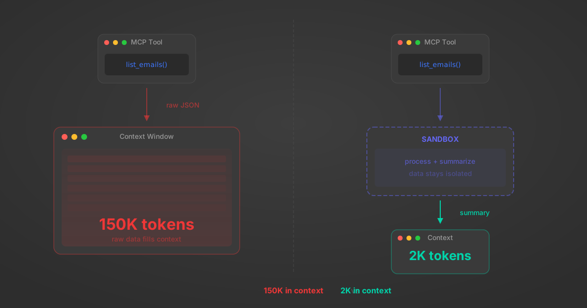
MCP Code Mode: Keeping Tool Responses Out of Agent Context
Anthropic's code_execution processes data already in context. Custom MCP code mode keeps raw tool responses in a sandbox. 14K tokens vs 500.
11 min
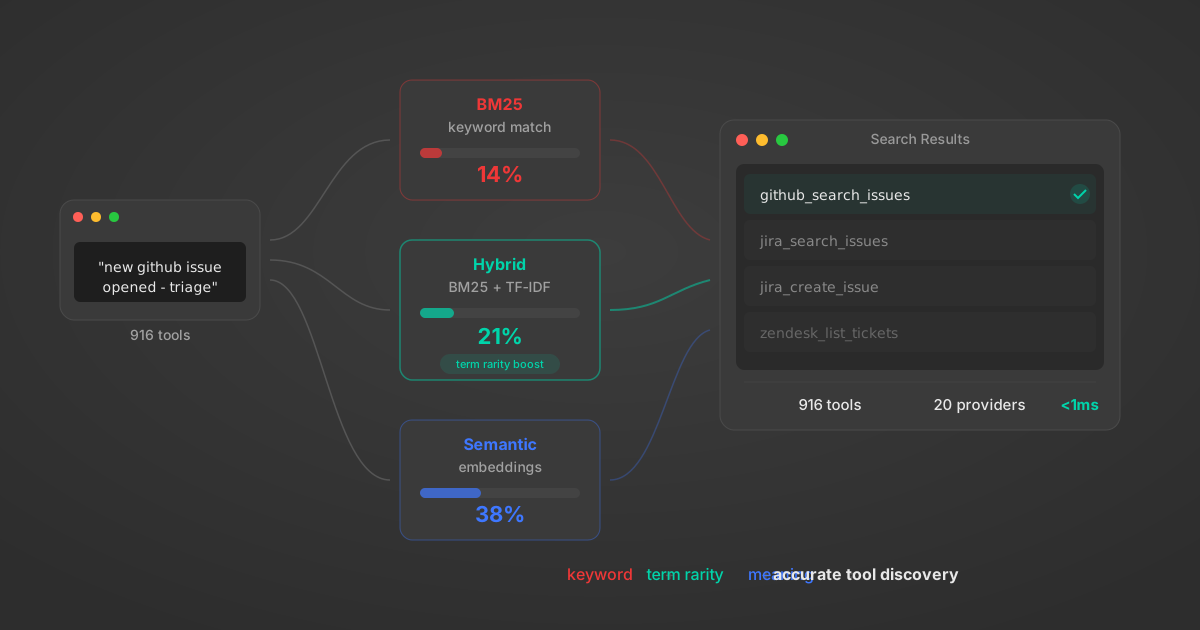
Comparing BM25, TF-IDF, and Hybrid Search for MCP Tool Discovery
Benchmarking BM25, TF-IDF, and hybrid search for MCP tool discovery across 916 tools. The 80/20 TF-IDF/BM25 hybrid hits 21% Top-1 accuracy in under 1ms.
10 min
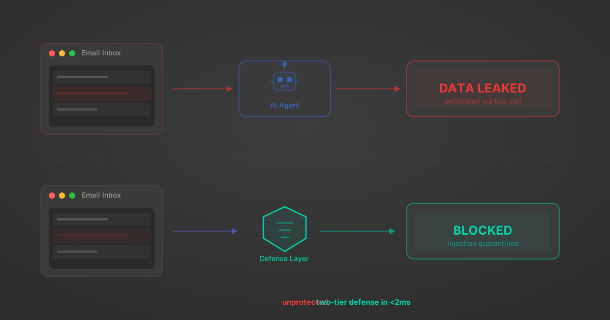
Indirect Prompt Injection Defense for MCP Tools: A Technical Guide
MCP tools that read emails, CRM records, and tickets are indirect prompt injection vectors. Here's how we built a two-tier defense that scans tool results in ~11ms.
12 min
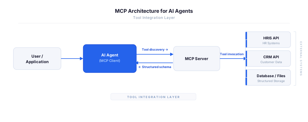
MCP vs A2A: Architecture, Security, and When to Use Each
MCP vs A2A: what each protocol standardizes, how they differ, their shared security risks including indirect prompt injection, and when to use one, both, or a hybrid architecture.
12 min
MCP vs API: What Hundreds of Connector Builds Taught Us
MCP wraps APIs, it doesn't replace them. After building hundreds of connectors that serve both, here's when each approach wins.
14 min read
Google Maps MCP Server FAQ
Does StackOne have a Google Maps MCP server?
Google Maps MCP server vs direct API integration — what's the difference?
How does Google Maps authentication work for AI agents?
origin_owner_id.Are Google Maps MCP tools vulnerable to prompt injection?
What is the context bloat of a Google Maps agent and how do I avoid it?
Can I limit which actions my Google Maps agent can access?
Can I create custom agent actions for my Google Maps MCP server?
When should I NOT use a Google Maps MCP server?
What AI frameworks and AI clients does the StackOne Google Maps MCP server support?
Put your AI agents to work
All the tools you need to build and scale AI agent integrations, with best-in-class connectivity, execution, and security.